


| SERVICES | LiDAR MAPPING | |
Photogrammetry |
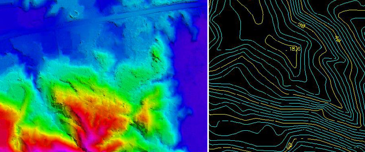
Our technical/project team have executed several large LiDAR mapping projects, below is a brief description of one of the initial project executed successfully. The total Project surface (area) is around 194 KM2 Lidar classification & 710 KM2 of Orthophoto generation. 194 Km2 of LiDAR bare earth classification is covered within the 710 Km2 of Orthophoto extent, where the client provided a less accurate DTM data for Ortho rectification only. The input LAS data provided by client will be adjusted & auto classified which needs to be further classified based on the specification provided, The LiDAR bare earth classification is processed in order to meet 0.5 mtr contours.
16 cm GSD Ortho rectification is performed using the classified bare earth lidar data, Aerial Imageries & the AT results, if needed edit the auto generated seamlines, then the ortho mosaics are cleaned up (seam lines, radiometric correction & overall color balance & Edgematched) Finally cut the mosaics for 1 sqkm by 1 sqkm tile with an overlap of 1 meter between all the tiles. Then 0.5 m Contours are generated using ground classified lidar data, using the best parameters where in the resultant contours have less spikes, smooth without compromising the spatial accuracy, and edit the contours near water bodies to depict a more natural surface, and then place spot elevations on tops & bottoms also around 100 meter apart in flat areas with more natural look. The final deliverable contours needs to be met with more detailed specification provided by client. |